EIA Costa Rica Miravalles Geothermal Field
 The Miravalles Geothermal field is located in the north of the country at the Miravalles Volcano in Bagaces, in the province of Guanacaste. In this geothermal field we find the Miravalles I, Miravalles II, and Miravalles III power plants. The Environmental Impact Assessment (EIA) for the Miravalles project was done in 1988. The importance of this project is that it was the first EIA ever done on history of Costa Rica but it does contain all the environmental consideration in the modern methodology of the EIA including the social aspects.
In Costa Rica all projects need to obtain permission from the Ministerio de Energia, Ambiente, and Telecommunications (MINAET). The MINAET classifies projects in three categories low, moderate, and high impact significance. Low impact significant projects only need an environmental declaration, moderate impact projects an environmental management program and high impact projects would require a partial or full EIA depending on the importance of the impacts.
The main activities in the development of the project were the well location, the site building, the well drilling and concludes with the well production test. Through a matrix of identification of environmental impacts the main risks identified in the productive process of the power plants were effects over the Fauna, Deforestation, Landscape, Air pollution, Noise, Visual Impact, Water pollution, Soil Pollution, and Waste. However the main impacts of project are noise accounting for 22% of the total impact the project will have, second comes soil pollution with 15%, and third water pollution with 14% of the total impact. The last two due to possible leaks hazardous materials like oil gas or chemical products.
 It is also important to mention that the project developer Instituto Nacional de Electricidad (ICE) efforts for environmental protection didn’t stop with the initial EIA and continues with and ISO 14000 Environmental Management System (EMS) in 2002. This ensures the continuous revising and improvement of the plant regarding environmental issues. The EMS resembles the Deming cycle with a few changes. It starts with Identifying and evaluating the environmental impacts, Planning of the environmental programs, Doing (implementation), Checking and monitoring, Acting (improvement of the programs), and the addition of policy making for the power plants. The aim of this is to identify new impacts that may arise in the productive processes, and reduction and mitigation of the actual impacts. As well as the systematization and improvement of impact identification, environmental programs, public relations, legal accomplishment, and environmental performance.
The relevance of this project for environmental performance in the country consists in that it doesn’t stop with EIA at the begging of the project but that of the consistent and sustained effort of the administration to commit to its environmental responsibility through the EMS. This is essential in order to prevent future environmental disasters and also enables the project to adapt to the continuous tightening of environmental laws.
References:
ENVIRONMENTAL IMPACT CONSIDERATIONSFOR GEOTHERMAL DRILLING, Hartman Guido Sequeira, Instituto Costarricense de Electricidad, Centro de Servicio Recursos Geotérmicos, Guayabo de Bagaces, Guanacaste, COSTA RICA
Comments Off on EIA Costa Rica Miravalles Geothermal Field /
08 Feb 2012
por
Javier Solano Palacios
 IMSD /
Santurbán Project – Gold extraction in Colombia
In 2011 the Canadian mining multinational Greystar Resources proposed to develop an open-pit gold and silver mine in a place called the Santurbán Paramo in the province of Santander, Colombia. The objective was to extract 11.5 million ounces of gold and 61 million ounces of silver over 15 years. 12% of the profits were for the Colombian government and the rest for Greystar. The Santurbán project caused a lot of controversy because it was supposed to be located in an ecologically sensitive area that is between 3,000 and 5,000 meters above sea level and that provides water to 20 municipalities an to Bucaramanga, the main city in the region (800,000 inhabitants).
 In order to develop the project the company proposed to excavate more than 2,700 acres, to construct two piles of tailings and dump at an altitude of 8,500 to 13,450 feet. Some of the related activities activities and resources were:
• Doing a 656 feet hole, removing 1,075 tons of rock (775 million tons will be dumped and 300 million tons will go to two leaching water basins)
• Using 0 .25 kilograms of explosives to per ton of rock removed / hour
• Applying 4,500 – 5,000 cubic meters of sodium cyanide / hour in each water basin
• Using 250,000 liters of water per hour for the mining process for free
Since the paramo is a source of water collection, filtration, control and recharge, the main threat of the project was the water supply. It would produce negative effects for farmers and cattle-raising, insecurity for residents of several communities, reduction of groundwater supply and aquifers depletion. Furthermore, the use of sodium cyanide can represent a serious risk for all living organisms in the area, especially considering that the Santurbán paramo lies in a highly active seismic zone.
But not only the negative environmental impacts were considered to evaluate the project. The company had strong arguments to support the project such as employment generation, opportunities for schoolchildren, welfare for people and economic growth for the region.
Several actors were involved in the analysis of the Santurbán project, including the company (also in charge of assessing the environmental impact of the project), the Colombian Ministries of Environment and of Mines and Energy, the local authorities, the Humboldt Institute (environmental organization), the ADAN NGO and representatives from the communities. More than 2,000 people participated in the project discussion.
Protests of more than 20.000 people against the project took place in the country and the media took an important role in communicating all the news related to Santurbán project. Even though the company proposed the alternative of underground exploitation, the Colombian government declared the Santurbán project non-viable and decided not to grant the license to Greystar.

I consider this refusal a very important achievement for the Colombian government, which now seems to understand that this kind of projects can only be implemented with a strict regulatory framework and under international sustainable practices.
Sources
Gobierno descarta “por completo” proyecto de Greystar en Santurbán. Semana Magazine. March, 2011. More information: http://www.semana.com/nacion/gobierno-descarta-completo-proyecto-greystar-santurban/153835-3.aspx
Laun, John. Report in Santurbán Mining Project of Greystar Resources. March 2011. More information: http://colombiasupport.net/2011/Greystar-Santurban-Mining-report.pdf
Proyecto en santurbán es inviable. El Espectador Newspaper. 2011. http://www.humboldt.org.co/iavh/component/k2/item/227-proyecto-en-santurb%C3%A1n-es-inviable?tmpl=component&print=1
Comments Off on Santurbán Project – Gold extraction in Colombia /
08 Feb 2012
por
Laura Rubio
IMSD /
Rural Development: Freshwater Depletion
Fresh water is necessary for all living species on Earth, after all, that is the only thing that sets this planet apart from others. Seeing water everywhere, and having it readily available in the developed world, has made water seem like an abundant commodity. This notion, however, couldn’t be more false.
 The water that covers the surface of our planet is 97% saline water, the other 3% of fresh water, which is the resource we rely on the most, is found in surface water (0.3%), ground water (30.1%), icecaps and glaciers (68.7%), and others (0.9%), such as water vapor and clouds. From the surface water that is utilized, much of it is found in lakes (87%), swamps (11%) and rivers (2%).
Unfortunately, much of the 30.4% freshwater that is more readily available for consumption is channeled to mainly agriculture. In fact, 67% of this water goes towards irrigation, food production, and farming. The rest goes towards industry, households and water supply. Considering that much of this precious resource is sucked up by our food supply, it is very important to evaluate its efficiency and quality.
The current agricultural picture is dramatically inefficient. Many big crops such as rice, cotton and sugar require high quantities of water, but produce little yield. For instance, to grow just 1 kilo of rice, a farmer must use 5,000 liters of water. On a global scale, growing rice in 2008 required 394 million metric tons of water. (Ronca)
 In addition to high water absorbing crops, which are economically unprofitable but are continually grown thanks to government subsidies, the current drainage and irrigation system results in much water waste. “The World Wildlife Fund estimated that only 20 – 50% of water extracted for farming actually reaches the crops.” (Ronca) This inefficiency results from agricultural land that is not flat on which water travels downhill, becoming unreachable for crops in the higher area. Switching to a more specific irrigation system, such as drip irrigation, where water is flown through a feeder to specific areas, ensures that the water is distributed with higher control and efficiency.
The biggest concern, however, lies in the pollution of the freshwater used for agriculture. When this water runs off from the land it is rich in pesticides, livestock manure and other chemicals which pollute other water channels, negatively impacting the entire water cycle. High amounts of this toxicity will result in the complete inability for humans to utilize the limited resources of freshwater.
 This issue is becoming more alarming as water demands increased. The director of International Water Management Institute, Frank Rijsberman, mentioned that: “globally, water usage has increased by six times in the past 100 years and will double again by 2050, [which is] driven mainly by irrigation and demands of agriculture.” The future scenario of water supply is not just a speculation. In fact, “many countries have already ran out of water to produce their own food”. (Guardian)
If more efficient and cleaner measures are not implemented, the production of further food for consumption will face even great obstacles. The continued increase of population will put a higher demand on food and without the ample supply of freshwater this will be impossible. Increased concerns of water wars, global protests and violence around water are all a probable reality.
The bottom line is, humans need their food, but without freshwater no living species will survive. It is important to start using our scarce and valuable resource wisely, and no change is more vital than in the agricultural sector.
Work Cited:
Ronca, Debra. (2011). “What’s the biggest threat to freshwater habitats?” How Stuff Works. Accessed on February 6, 2012 from: http://adventure.howstuffworks.com/outdoor-activities/fishing/fish-conservation/fish-populations/freshwater-habitat-threat1.htm
USGS. (2011). “How much water is there on, in, and above the Earth?” Water Science for Schools. Accessed on February 6, 2012 from: http://ga.water.usgs.gov/edu/earthhowmuch.html
USGS. (2011). “Earth’s Water Distribution.” Water Science for Schools. Accessed on February 6, 2012 from: http://ga.water.usgs.gov/edu/waterdistribution.html
Vidal, John. (2006). “Cost of water shortage: civil unrest, mass migration and economic collapse.” The Guardian. Accessed on February 6, 2012 from: http://www.guardian.co.uk/environment/2006/aug/17/water.internationalnews
Comments Off on Rural Development: Freshwater Depletion /
08 Feb 2012
por
Hokuma Karimova
IMSD /
Innovation: Opening doors to ideas
 The importance of innovation has never been so critical as it is today. In today’s fast paced world, where new technologies, new trends, ideas, social media platforms and companies of all sizes come and go, it is vital for any organization to be flexible. Learning to adapt to the latest trends, the needs of the clients and demands of the market, determines whether one survives or is buried under a pile of everything “new”.
At the moment, there are two main techniques with which an organization, individual or a company can stay ahead and be innovative. These techniques are ‘lead user innovation’ and ‘open innovation’. The first technique, lead user innovation, relies on the employment of users who are well educated in the market they are working on. These users will have the following two characteristics, they will: “ face needs that will be general in a marketplace – but face them months or years before the bulk of the marketplace encounters them; and expect to benefit significantly by obtaining a solution to those needs”. (von Hippel)
The second technique, open innovation, relies on the companies implementation of outside inputs when creating a new idea. These inputs can come from consultants, other organizations and most importantly, directly from the clients. There are three ways of implementing these different ideas, “crowd-sourcing, user-driven innovation and co-creation, all tools and techniques that are used within the paradigm of open innovation.” (Lindegaard)
 The three techniques of open innovation address the different aspects of implementing outside sources in the creation and execution of a new product. Firstly, the use of crowd-sourcing relies on the marketing of an idea, and the utilization of the clients ideas for the creation of a product. The user-driven innovation comes from analyzing the behavior of the user, and addressing their needs through gathering information and pattern of product use. Finally, co-creation is the process where the company and the client work together to update an existing product and make it more efficient.
Whether a company or an organization rely on open innovation or lead user techniques, the bottom line is, the birth of good and brilliant ideas come from networking. It is the exchange of thoughts, ideas, and spur of the moment creativity that lead to market changing products. These products are created not only by the company, but also by the clients who use them on a daily basis and have a good vision of what can be added or taken away to make their favorite product even better.
In a world of cut throat competition, and ever changing ideas, staying ahead of the pack determines the survival of a company. By not being afraid of opening ones doors to new ideas and changes, and through the correct utilization of these techniques, any company can see a successful and profitable future.
Work Cited:
Hippel, E & Riggs, W. (1996). “A Lead User Study of Electronic Home Banking Services: Lessons from the Learning Curve.” MIT. Accessed on February 7, 2012 from http://web.mit.edu/evhippel/www/papers/evh-01.htm.
Lindegaard, S. (2011). “Making Open Innovation Work.” Stefan Lindegaard. Accessed on February 7, 2012 from http://www.15inno.com/2011/10/28/free-book-making-open-innovation-work/.
Comments Off on Innovation: Opening doors to ideas /
08 Feb 2012
por
Hokuma Karimova
IMSD /
EIA: Can Mining activity be strategically Sustainable?
An interesting case to talk about Environmental Impact Assessment processes is the one involving a mining company in Australia, Iluka Resources Limited, involved specifically in “exploration, project development, operation and marketing of mineral sands products”, as they inform in the website.
Nowadays mining activities are particularly under strong criticism, as the sector is often considered unable to decouple the generation of economic value from the consistent environmental and social distress likely to be experienced along the project and beyond. A valuable verification of this complexity is expressed for instance by the Conga mine case in Peru, which has been recently paralyzed due to strong community opposition, specifically regarding water supply and pollution of waterways.

Nonetheless, the mining sector has not been always under such pressure: Iluka is said to have fulfilled Environment Protection and Biodiversity Conservation, when implementing a project in the Cataby region of Western Australia in 2005. The company provided detailed plan that identified the likely impacts of its activity on the listed species, and defined measures of avoidance and mitigation to minimize them, as suspending mining adjacent to nest areas during the breeding season of a listed endangered bird species.
The company participates with success also in bigger projects: Authorities in the Murray Basin in north-western Victoria convened approval for expansion of activities in the area, as the “Murray Basin-Stage 2” in 2009.
From a first overview of EIA submitted, while the report appears very concerned regarding main issues as water and biodiversity impacts, I am particularly interested in the objectives related with CO2 emission reduction. Actually, although emission from energy use and transportation during the project implementation are dealt with, no citation is referred to fugitive emissions, which in Australia account for a consistent share of the total.
In addition, from a strategic point of view which should align with long term ecological sustainability (as claimed by objectives 9 and 10) the minerals themselves are a huge concern that find no response: actually heavy minerals and fossil fuels have been sequestered in the lithosphere during million of years processes, in which ecosystems of the earth have been phasing out such toxic substance for life. Reintroducing into ecosystems such materials creates enormous health and environmental issues, as they do not break-down easily in nature and accumulate overall in plants and fatty tissues of animals. Concentration of substances coming from the earth’s crust is a well-known cause of humans’ major diseases.

Consequently my point is: why such considerations are not included into environmental policies and assessments?
The only solution I see is the implementation of a shared responsibility strategy along all the value chain of such substances, from extraction to disposal. Humanity can still enjoy every benefit related to the use of metals, minerals, and fossil fuels, but the only sustainable way is avoiding accumulation of them into ecosystems.
Comments Off on EIA: Can Mining activity be strategically Sustainable? /
07 Feb 2012
por
Francesco Mazzeo
IMSD /
Environmental Impact Assessment (EIA): Nord Stream Pipeline
Brief Background on Case Study of Nord Stream Pipeline
Nord Stream is a 1,224-km twin pipeline system that is currently underconstruction and is being built to run through the Baltic Sea in order to transport natural gas from Russia to Europe. It is considered as the direct connection between the gas reserves in Russia and the EU’s energy markets.

Nord Stream Pipeline
The 10-billion dollar project is handled by Nord Stream AG – an international consortium of five major companies, which are OAO Gazprom, Wintershall Holding GmbH (a BASF subsidiary), E.ON Ruhrgas AG, N.V. Nederlandse Gasunie and GDF SUEZ. Nord Stream AG is based in Zug, Switzerland and was established in 2005 specifically for planning, construction and operations of the gas pipelines.
Due to the transboundary nature of the Nord Stream Pipeline, extensive consultations were conducted with the five countries – Russia, Finland, Sweden, Denmark and Germany, from which permissions were required before construction of the pipelines could commence. However, Estonia, Latvia, Lithuania and Poland were also invited to become a part of the consultation process because the project may also affect their countries.
The Espoo Convention is an agreement that was adopted in 1991 by the United Nations Economic Commission for Europe. It sets out obligations for parties to assess the environmental impact of projects at an early stage of planning and binds signatory nations to notify and consult one another on grand projects that are likely to have significant environmental impact across boundaries.
Since the Nord Stream Pipeline project involved nine Baltic Sea nations, the Espoo Convention served to remind all the countries affected to review the project’s potential impact. National legislation thus called for an Environmental Impact Assessment (EIA) to be completed before a national permit for the project could be granted. Hence, Nord Stream conducted various surveys and studies on the Baltic Sea seabed and ecosystem and as a result, the Nord Stream Espoo Report was prepared and published in 2009.
This EIA report is set in a transboundary context with emphasis placed on protecting the environment, and allowing for response from the public and other stakeholders. According to nord-stream.com, some examples of the mitigation measures that were undertaken are the “avoidance of sensitive sites, the scheduling of construction activities to avoid the breeding periods of seabirds and spawning periods of fish, and the use of control measures to manage the spreading of sediments”.
(Click here to download and read the report)
In addition to the agreements established with the countries involved, Nord Stream also launched an environmental monitoring programme at the beginning of the pipelines’ construction in April of 2010, and is planned to continue monitoring the progress of the pipeline through 2016.
The first pipeline (Line 1) has already been completed and delivery of gas from Russia began in November 2011. Both lines of the Nord Stream Pipeline system is expected to be operational by the end of 2012. According to the Nord Stream website, the pipelines combined will be able to deliver up to 55 billion cubic metres of gas annually.
(Source: http://www.nord-stream.com)
Click below to watch a news report on the project partners and European leaders turning the “valve” at the inauguration of the first pipeline, as well as some inputs on EU energy security.
Click here to view the embedded video.
Comments Off on Environmental Impact Assessment (EIA): Nord Stream Pipeline /
07 Feb 2012
por
Syafrina Sharif
IMSD /
The Impact of the Palm Islands, United Arab Emirates

“significant changes in the maritime environment [of Dubai] are leaving a visual scar [. . .] As a result of the dredging and re depositing of sand for the construction of the islands, the typically crystalline waters of the gulf of Dubai have become severely clouded with silt. Construction activity is damaging the marine habitat, burying coral reefs, oyster beds and subterranean fields of sea grass, threatening local marine species as well as other species dependent on them for food. Oyster beds have been covered in as much as two inches of sediment, while above the water, beaches are eroding with the disruption of natural currents” (“Dubai’s artificial islands have high environmental cost”).Despite other criticisms of Dubai, there is a significant amount of truth in Mongabay.com’s statements. The World Wildlife Fund made a similar announcement in 2006, declaring “UAE’s human pressure on global ecosystems (its ecological footprint) to be the highest in the world. The country is currently five times [in 2007] more unsustainable than any other country” (. It would be impossible to say that the effects of the islands have not been felt by the surrounding environment since the start of their construction, and will not continue to be felt into the future. So in order to properly manage their shorelines and effects, Dubai relies on its very comprehensive coastal monitoring programme. Established in 1997, the Dubai coastal monitoring programme began studying the baseline bathymetric and topographic survey of the Jumeirah coastline. However, since then better technology and more additional data was able to be collected, including remote video monitoring of Dubai beaches, sediment sampling and analysis, near shore directional wave and current recordings and intensive measurement exercises at selected locations using Acoustic Doppler Current Profiler (ADCP) equipment. Below is a breakdown of those methodologies of monitoring and what they survey and measure. Bathymetric and Topographic Surveys First, the Dubai coastal zone has been divided into different regions for more organized monitoring. The frequency of the surveys in a region is determined by the environmental risks that the particular region poses. For instance, areas more affected by coastal erosion or inundation are monitored more than those that are less likely to not be affected. The bathymetric survey covers a 500m wide band along the entire coastline with survey lines that run perpendicular to the coast, 25 m apart from each other. A dual frequency echo sounder and differential GPS are used to collect data along these lines. Some of the data obtained deal with sediment budget and transport systems. Topographic surveys are carried out using a pre-defined set of profiles that run perpendicular to the shoreline down to mean water level +1.13m DMD (Dubai Municipality Datum). Scatter point surveys are also completed at 10 locations along the coast to produce a contour map of the beach. Data is also collected by Real-Time Kinematic Geographical Positioning Systems (RTK GPS).
Near shore Wave Measurements 1,200 kHz ADCPs with pressure sensor have been stationed at a near shore position north of Jebel Ali Port in 6 m water depth and off the Jumeirah Public Beaches, providing directional wave information in the region of the most immediate interest to the Municipality. “The instrument measures currents throughout the water column using the return echo of an acoustic signal transmitted by the instrument. The instrument not only provides valuable information to the Municipality, but also to the general public via internet. A pressure sensor was also installed behind the northern arm of the T breakwater to provide information on water levels within the sheltered embayment. Variations in water depth (pressure head) induce corresponding resistivity readings in a piezo-electric device in the instrument. The value of resistance measured is proportional to the depth of water. The data reveals a lot about coastal hydrodynamic processes occurring along the coast, to calibrate or verify hydrodynamic models as well as to assess bather safety concerns.” Video Monitoring On the thirty-fourth floor of the Burj Al Arab hotel, which is located offshore on the Dubai coastline are two installed video cameras that take time-lapse snapshots of beaches using GPS corrected control points. Once the images are processed, and control points are established, a representative water line is determined. So far data from the video cameras have just been used for verification purposes to measure the accuracy of extracted water levels from images to real survey data. However, now these images will be used in designing profile dynamics and exploring bar dynamics and the extraction of near shore current patterns using cross-image correlation. Meteorological Data There is a a meteorological station at Jumeirah Open Beach that helps provide information on wind speed and direction, barometric pressure and air temperature. The station is run by EmuDome Dubai Environmental Monitoring System (EDEMS), a custom built software package. EDEMS allows easy access to transfer of this useful information between a client and project team via internet. Sediment Sampling Sediment Samples are collected along all of Dubai’s beaches and near shore zone and are analyzed according to grain size, fall velocity, allowing scientists to make many conclusions about the coastline evolution, sediment transport and morphological models set up for the region. Coastal Monitoring of the Palm Island Area The construction of the artificial islands have altered the Dubai coastline. For instance, the construction of Palm Jumeirah has caused the coastline in the southwest shadow of the island to grow very quickly. Wave models reveal that the northerly waves are removed from the near shore wave regime at Mina Al Seyahi through the existence of the Palm island. With this removal, north-eastward transport rate is greater and as a result, there is a build-up of the coastline. However, on the other side of Palm island, the reverse occurred. The coastline here had been retreating because the harbour blocked movements of sediments travelling from the southwest and the north easterly transport had gradually eroded the beach. With the removal of waves from the north-west by the construction of Palm Island, Northerly waves “become” relatively stronger. Thus, the reverse effect is obtained here, resulting in lots of erosion (an illustration and more basic analysis of this phenomenon can be found on the Construction of Palm Islands page).
Source: https://sites.google.com/site/palmislandsimpact/
Comments Off on The Impact of the Palm Islands, United Arab Emirates /
07 Feb 2012
por
Luca Palma
IMSD /
EIA/SEA: The road to development- is it paved with good intentions?
Azerbaijan, a country that in 1991 declared independence from the Soviet Union, is looking to expand and strengthen its trans-national trade. The proposed “Masalli-Astara” motorway, (which will be funded by the World Bank, the Asian Development Bank and the Republic of Azerbaijan), looks to upgrade an entire 240 km of existing highway known as M3. This road will increase trade between Russia and Iran, helping to revive the trade, strengthen the economy and create new employment opportunities. However, the main question is: “At what price?”

Despite the many economical benefits of the project, the main concern lies in the negative environmental, social and health impacts. The fact that the government is considering this project to be so important that no ‘without project’ scenario was discussed shows how political interests outweigh any other concerns.
The Environmental Impact Assessment Report from September 2011, listed the following as areas of concern:
– destruction of trees found in the Red Book
– aggravation of a national nature reserve housing indigenous plants and trees
– division and displacement of communities
– decreased food production from channeling agricultural land to other uses
– spread of sexually transmitted disease, such as HIV/AIDS
– noise and vibration impacts
– water, air and soil pollution
– negative long-term cultural impacts due to increased traffic
– possible destruction of historical, cultural and archeological sites
– lack of representation and participation of the local community
 The EIA report, concludes that the “anticipated adverse environmental impacts can be minimized to acceptable levels through the implementation of adequately funded environmental management and monitoring”. (Report, pg 75) However, the report goes on to state that “the entire environmental program at the Azerbaijan Road Service, (which will be responsible for monitoring), is still more a concept than a reality, [and] none of the specified monitoring functions by the designated agencies have been satisfactorily performed in-country.” (pg 65) The lack of skilled technical staff with, little previous experience of implementation and management of such projects, demonstrates that once the project starts, there will be a high probability of low transparency, accountability and monitoring.
Without the necessary and adequate mitigation skills, any probable negative impact could become extremely dangerous. The process of complaint, in case such incidents occur, is long and bureaucratic, making any incident of violation hard to prove and prevent.
This case is a perfect example of the price developing countries are willing to pay to increase their economy, despite the obvious social and environmental price tags these projects carry. The question is: “What will be more beneficial in the long-run, executing the project or safeguarding the environmental and social interests?” It is worth discussing this case further to examine the answers.
Work Cited:
ADB. (2011). “AZE: Road Network Development Program Masalli-Astara Motorway.” Asian Development Bank. Accessed on February 7, 2012 from: www.adb.org/documents/Environment/AZE/…/39176-023-aze-eia.p.
Comments Off on EIA/SEA: The road to development- is it paved with good intentions? /
07 Feb 2012
por
Hokuma Karimova
IMSD /
Environmental Impact Assessment: MAT case
In 1994 a power supply agreement was signed between France and Spain. This is the starting point of the line MAT Sentmenat – Bescanó -Baixas. This agreement was declared as a “community interest” the project of a new line of high tension between France and Spain, which would fit with the proposal of an internal market in electricity. The Spanish Electricity Network (REE) and the Electricity Transport Network (TEN) French were in charge of the project and have tried since 1997, to develop a high voltage line crossing the Pyrenees, adding it to the seven interconnection power lines between France and Spain (two of which are 400 kV). The opposition in different places has prevented the project on the border of these countries, although the Iberian electricity system has developed.

Source: (Territori, 2007)
Most mayors of the municipalities where the MAT is going to come are positioned against it until a set of clarifying questions.
The Generalitat de Catalunya said it promoted the construction of the MAT for three main reasons:
1) Need to improve electricity supply in the surrounding region.
2) The high speed train (TGV) line needs a very high voltage (400kV) to function.
3) It is necessary to increase the interconnection capacity with France.
However, the coordinator of the electrical interconnection between Spain and France, Mario Monti presents other arguments:
- Security of supply
- The need to ensure the stability of your network. Increasing the park
- renewable energy production (wind, hydro and solar) whose production is highly variable and unpredictable in the long run requires more interconnections to cope with the peaks or valleys of production.
- The need to lift the region of Girona of electrical insulation, which exposes this area, more than any other in Spain, the risk of serious power shortages.
On the other hand, there are different political and social actors who oppose the construction of high voltage lines for different reasons. The reason are basically, that the project must not applied until proven extensively with a broad debate, transparent and multidisciplinary, in agreement with local governments and with the participation of independent experts and the social and economic needs exist local energy supply and that only and exclusively, can be covered with this line, that is not viable options or other energy models.
Other groups demand a new energy culture, more efficient, more decentralized, more renewable, less CO2-emitting nuclear waste.
The main impacts considered are:
Impacts on the land and the environment: From tower to tower it will create a lane width of 4 meters to lift the cables, but the goal is to avoid it when you can do with a helicopter. And at the base of the towers the trees have to be cut in an area of 15 by 15 meters. The technicians who install the tower have promised to the owners that they will not cut more more trees than the supplanted ones by the towers, because of the wires were installed by helicopter, but there is no written document consigning this commitment.
Effects of electromagnetic fields (EMF) on public health: Another key point that has raised doubts and contradictions regarding the power lines are its effects on health. The most recent research is showing that electromagnetic pollution may have effects on health.
Socioeconomic impacts: Regarding to the socioeconomic impact, the report of the European mediator Mario Monti rejected the argument that the territory “would make no direct benefit from the project” but admits a “loss of enjoyment of part of territory due to the power line.” In this sense, Francisco (Association of Municipalities MAT (AMMAT) indicates that “we must consider if the infraestructure mortgage the socio-economic future of the area: the construction of the MAT cancels any possibility of the affected areas to engage the rural tourism and lose one of its main assets; the nature ”
References:
Dossier sobre la Muy Alta Tensión (MAT) en Catalunya Contextos, Actores, Contradicciones y Alternativas. De la Muy Alta Tensión (MAT) a la Generación Eléctrica Renovable y Distribuida (GERD). Equip NovaTerra’07
Territori. Observatori de Projectes i debats territorials de Catalunya. Retrieved 6/2/2012 from: http://territori.scot.cat/cat/viewer.php?IDN=254
Comments Off on Environmental Impact Assessment: MAT case /
07 Feb 2012
por
Carlos Cerdan Infantes
IMSD /
EIA: Nord Stream
![]() Nord Stream is a, or rather „the” gas pipeline that by the end of this year will connect Germany with Russia. The pipeline is being build offshore, thus avoiding the traditional and from an investment point of view rational land path. Because of its offshore positioning it has raised a lot of controversy, not only because of its potential environmental impact, but also because of its political and ethical aspects.
Nord Stream is a, or rather „the” gas pipeline that by the end of this year will connect Germany with Russia. The pipeline is being build offshore, thus avoiding the traditional and from an investment point of view rational land path. Because of its offshore positioning it has raised a lot of controversy, not only because of its potential environmental impact, but also because of its political and ethical aspects.
Nord Stream is owned by Nord Stream AG, a consortium that joins Gazprom (51% of shares), BASF, EON, Nederlandse

Nord Stream pipeline path
Gasunie and GDF Suez. The contract between Germany and Russia was signed in 2005 and the final agreement of companies was signed in 2006 in Moscow. The whole pipeline is going through the Baltic Sea and is crossing only Russian and German waters. The economic zones through, which the pipeline is passing belongs to Finland, Sweden and Denmark, which all gave their permission. It is going to be the longest sub-sea pipeline in the world having 1,222 km long and it is going to be completely finished by the end of 2012.
Of course the main concerns came from the four countries that have been “ignored” during the construction (Estonia, Latvia, Lithuania and Poland). The whole project will cost €8.8 billion, while the onshore version would cost only €5 billion. It was explained that in long term it would be more profitable, because of the elimination of transit fees. For instance Ukraine alone will lose $720 million per year. It is also believed that Russia wanted to make a direct contact with Western Europe in order to have a higher influence on countries like Belarus, Ukraine or the Baltic Republics. It is highly influencing the energy security of those countries, as they may not have the support of the Western European countries (remember the Russian gas embargo on Ukraine in 2008).
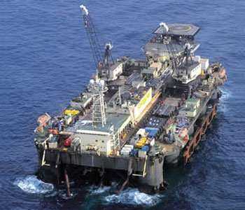
A special unit used to lie the pipeline.
As far as the potential environmental impact on the Baltic Sea is concerned the official Nord Stream website is confirming that each country, through out which the pipeline is passing have carried out an EIA with positive results. In reality there are two serious environmental concerns. The first one is obvious and is regarding the construction process. It is necessary to dig an excavation 15 m wide. It will have an impact on the fauna and flora and also on the biodiversity of the Baltic Sea ecosystem. It will fragmentize some habitats that are living on the rocks of the bottom of the sea. The other main concern is the fact that the sea bed was disturbed during the II World War with naval mines, chemical waste, munitions and toxins, and other items. Thereby those toxic substances may harm the particularly sensitive Baltic Sea ecosystem. Some of the mines where found by Nord Stream and were detonated under water.
Some ethical controversies were also raised along the project development. The former German Chancellor Gerhard Schroder signed the agreement with Russia few weeks before he stepped down offering €1 billion of guarantee. Even though the guarantee was never used, Schroder was chosen to be head of shareholder committee of Nord Stream AG. Same thing happend with the former Finnish prime minister Paavo Lipponen, who also worked for Nord Stream AG after accepting its way through the Finnish economic zone.
References:
- Nord Stream AG Official website – http://www.nord-stream.com/environment/
- “Wartime Mines to Be Cleared from Nord Stream Route” – http://www.downstreamtoday.com/news/article.aspx?a_id=13974&AspxAutoDetectCookieSupport=1
- “Nord Stream costs Ukraine $720 million” –http://www.upi.com/Business_News/Energy-Resources/2011/05/20/Nord-Stream-costs-Ukraine-720-million/UPI-83611305917575/
- “Nie chodzi tu o rentowność” – http://www.naszdziennik.pl/index.php?typ=sw&dat=20090210&id=sw24.txt
1 comentario /
07 Feb 2012
por
Piotr Adam Lubiewa-Wielezynski
IMSD /

.png)
].gif)
].png)
].png)
].png)
].png)
].png)
